Blog
Four post and six post structures
Many of the large excavations of Iron Age settlements in the UK have found evidence of post hole settings. These are often grouped in rectangular form and have been interpreted by archaeologists as ‘four post’ or ‘six post’ structures. These were thought of as stores for grain or hay. Some them are also thought as being racks for drying various agricultural products.
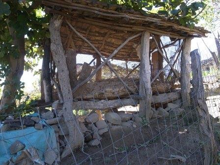
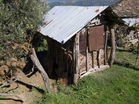
Imagine my surprise then, to see similar structures being used in a small Albanian mountain village, while on survey there this year. There were two six post structures, each with a roof and open sides to allow the crop to dry. In this case, it was maize cobs which need to dry in the Sun after harvesting. The floor of the structure is raised to assist with drying and also to keep vermin and probably, chickens raiding the store.
If these collapsed and the timber uprights rotted away, a six post structure would be left for a future archaeologist to excavate. The only difference to any of the UK example I know of is the stone wall built on the downhill side partly to retain the structure.
Training
Over the last year the staff have passed a number of courses and awards. These are NQV3 Office Management, NVQ4 Management and a management course level 4 run by the Institute of Leadership and Management (ILM).
This gives our staff the confidence to act here or in other companies. To show we mean it, at the moment, we are selecting new courses for next year.
Now to keep using the techniques we know and implement the new ones!
LiDAR Workshop Machynlleth 21st May 2010
IfA Wales/Cymru Group with the Royal Commission on the Ancient and Historical
Monuments of Wales/Comisiwn Brenhinol Henebion Cymru will be running a Workshop on Airborne Laser Scanning and LiDAR:
A practical workshop for archaeologists and heritage managers.
I will be speaking there, along with others who have much greater experience, so I hope to learn a lot, and I hope everyone else does.
For details, click here:
IfA LiDAR workshop May 2010 – programme
Laugharne Castle Lighting
The other night we were in Laugharne and parked below the castle. It was beautifully lit by a pair of white lights that created a mystical air of shadows and highlights that was smooth and easy to look at.
In recent years we have struggled with the design of an appropriate lighting for Cardigan Castle, the Laugharne lighting would have covered all the problems, including not being too intrusive for the bats (I’m sure they’re resident at Laugharne as well!).
Cadw are to be congratulated for this successful design!
Living With the River Project
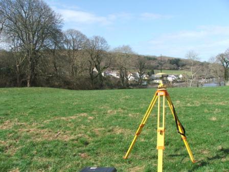
Landsker Archaeology has been working on this for a number of years. The main focus of the project is the measurement and study of sand bank formation in the Teifi Estuary and the difficulties of navigating boats up the river. We have been involved in annual surveys of the river at low tide to chart how the sand banks and bars move over time.
The archaeological element in this is the study of how the estuary has been used over time. One of the biggest assets of the project is the Lidar survey undertaken in March 2007, which has been beneficial in the study of earthwork sites along the estuary. We are now complementing this by topographic survey of those same areas to see if we can get a better picture of what they represent.
The first of these surveys is at Old Castle Farm near Cardigan. This is a fine motte and bailey castle on the banks of the Teifi. The outer part of the site is clear and shows as distinctive earthwork on the Lidar, however the motte is covered by trees and does not give a good reflection on the Lidar. Our survey is to gain as much information with the GPS survey unit before the leaves come out on the trees, and follow this up with measurement with the total station in places where there are too many trees to get good satellite coverage.
The end product will be a survey drawing compiled from the three sources, along with a statement on how effective each was.
Old Castle Farm Survey